Most of Poland’s territory lies in a post-glacial area, characterised by a considerable variability of soils, even their mosaic nature. It is not uncommon to find arable fields with soils of bonitation classes 1 and 2 next to soils of classes 5 and 6. The retention capacity of soils – apart from their organic matter content – depends strictly on their granulometric composition, i.e. the proportion of sand grains (0.05mm-2mm), dust (0.002mm-0.05mm) and clay (<0.002mm).
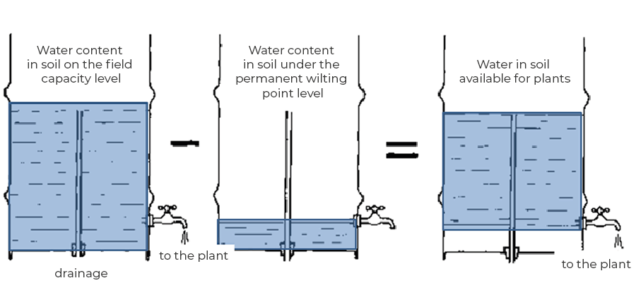
The soils were subdivided in terms of granulometric composition into soil types, which include sands, clays, silts and clays. It is assumed that the heavier the soil, the more silt and clay parts it contains and the more pores, or spaces, it has which are filled with air or water. Thus, the heavier the soil, the greater its water holding capacity; at the same time, the more water is hidden in very small capillaries, which plants have very difficult access to. The amount of water that a soil is able to hold in its pores is called the field water capacity. In contrast, the amount of water that is not available to plants because it is too tightly bound to the smallest pores in the soil is called the permanent wilting point. A prolonged drop in soil moisture below this point usually results in the death of the plant. Above the field water capacity, the soil can hold a certain, sometimes quite considerable amount of water – this amount fills all the pores in the soil completely, including the largest ones. Gravity causes the water filling the largest pores to drain away within 1-3 days into the soil profile, taking with it significant amounts of soluble compounds, e.g. potassium and nitrogen. This relationship is illustrated in the figure below:
For each soil, the characteristic moisture content, i.e. the points of permanent wilting and field water capacity, are different. The matter is further complicated by the fact that the soil profile is very rarely homogeneous and different subsoil types occur at different depths under the arable horizon. For the use of irrigation controlled by soil moisture measurement, it is sufficient to know the granulometric composition of the soil horizon in which the sensor is located. The soil species can be determined at the District Chemical and Agricultural Station or an experienced soil scientist, such as a soil classifier, can be asked to determine it organoleptically